Rethinking the Grid
Streetfilms - Dancing, Art, Music … & Bike Lanes on West End Avenue Open Street
Bar Crawl Radio Podcast - We Walk - Park(ing) Day - on West End Avenue

Source: Streetplans
Cars simply cannot be the future of cities. In a city that is growing and a world that is rapidly urbanizing, geometry will eventually outweigh personal convenience. Cars are the least spatially-efficient way to move about a city. They crowd out other, better, and healthier uses of space, and the more space they are given, the more they take up. It is time for the “post-car” city— a city where most streets are not for cars and most people don’t own one.
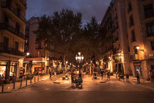
Redesigning the street grid returns space to people and human-scale uses in a larger-scale, organized way. The most famous example of this is Barcelona’s Superblocks, which limit through-traffic to every 4th block, turning inner streets into space for people walking, biking, playing, and socializing.

Seattle has started to reimagine the grid by creating a Street Type Matrix, which defines streets according to place and movement, allowing consideration for the surrounding neighborhood context and the street’s role in the transportation hierarchy.

In New York City, DOT created a Street Hierarchy in which streets are designated as Travel Streets, Community Streets, and Living Streets for the Downtown Brooklyn Traffic Calming Study. Travel streets “provide critical transportation links and allow for movement, while also serving as destinations in their own right for commercial, cultural and institutional activities.” Community Streets are less critical for through traffic and serve more as “Town Centers;” their primary purpose is to “improve the environment for pedestrians, cyclists, business owners and their customers, while facilitating some through traffic.” The city has also piloted “shared streets”-- of the kind found on the interior of Superblocks -- on Broadway in the Flatiron District and has plans to create one on Bowling Green in the Financial District.
Superblocks, Street Matrices, and Street Hierarchies--like Truck Routes before them--all recognize that there is a role for streets that accommodate vehicles—deliveries, cargo, even heavy equipment—but that does not mean all streets have to be designed for these uses. We have many more streets than are realistically needed for those automobile uses and too few streets for people and street life. Given the inherent difference between designing streets that are good for large, fast-moving vehicles and those that are good for small, slow people that means we have too many streets that are ill-suited for people and life. Systematically categorizing streets by function creates a logic that is easy to follow both for the planners redesigning the streets on a large scale and for the pedestrian navigating at street level.
Copenhagen’s redesign of its street grid started with one pedestrianized street, Stroget, in 1962. They gradually added more pedestrian-only streets and linked them to pedestrian-priority streets, where walkers and cyclists have right-of-way but cars are allowed at low speeds. They paired this with reducing the number of cars in the city by eliminating parking spaces at a rate of 2-3% per year. They added bike lanes and bike crossings – using space freed up by the elimination of parking – near intersections to create a city renowned for a human-scale transportation environment.
In Barcelona, the pace of the redesign has been much more ambitious. While the first Superblock was built in 1993 and the next two in 2003, they have gained momentum since 2014. That year, the city developed an Urban Mobility Plan, designed to give the city back to people, which called for the implementation of 500 Superblocks across the city. Since then, two more have been completed, five are under construction, and another ten are in the planning stages. While opposition does crop up, it quickly dissipates once residents experience the benefits of more public space, more community, quieter neighborhood streets, and easier access within and across neighborhoods.
A full redesign of the street grid on the Upper West Side won’t happen overnight, but Barcelona’s progress since 2014 shows that it can happen quickly. The Upper West Side is an ideal location for a Superblock-style redesign given its regular pattern of commercial and residential streets and human-scale density. Building on Streetopia UWS’s campaigns including Pedestrianizing Broadway, Reclaiming the Curb, and Daylighting will lay the groundwork for a larger-scale reimagining of the street grid throughout the Upper West Side.
Source: New York Times.